19.85.006 Form and appearance.
A. Form and Appearance Objectives. The following objectives shall serve as guidelines for use of land and water resources to preserve a sound natural environment:
1. Preserve existing wetlands in a healthy state to ensure the aesthetic enjoyment of marshes and the wildlife that inhabits them.
2. Change the existing industrial image of the Bayfront and develop a new identity consonant with its future prominent public and commercial recreational role.
3. Improve the visual quality of the shoreline by promoting public and private uses that provide proper restoration, landscaping, and maintenance of shoreline areas.
4. Remove, or mitigate by landscaping, structures or conditions that have a blighting influence on the area.
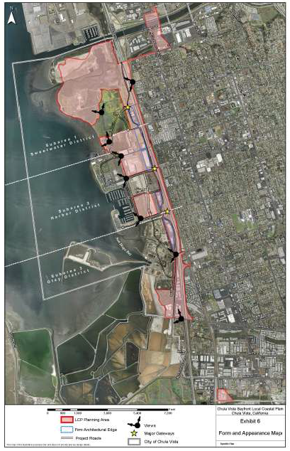
5. Eliminate or reduce barriers to linking the Bayfront to the rest of western Chula Vista and establish a memorable relationship between the Bayfront (and the areas and elements that comprise it) and adjoining areas of Chula Vista, the freeway, and arterial approaches to the Bayfront (see Exhibit 6, Form and Appearance Map).
B. Specific Provisions. To promote these requirements, the form and appearance provisions of the LUP acknowledge three major components that comprise the physical form of the area: natural resources areas to be preserved; a public space and recreation system, including walkways, bicycle ways, and park areas; and development units having common usage and/or qualities, which should be treated as distinctive, but closely interrelated, visual entities.
1. Landscape Character and Function. Major landscape components shall establish strong visual continuity in response to varied functional needs. Landscaping will incorporate both hardscape features and softscape (planting).
2. Dense Landscape Planting. All areas designated for dense landscape planting shall include dense planting of trees and shrubs to serve three purposes: diminish the visual impact of large existing industrial structures, such as those of Goodrich and SDG&E’s power plant and transmission towers, and extensive parking areas and outdoor storage areas; define major entry points to the Bayfront and frame views; and be used in masses as visual stopping points to limit views and provide natural vertical elements. Heights of trees and shrubs may be limited by USFWS requirements in areas near the wildlife refuge.
The following standards shall guide dense landscape planting design:
|
Location |
Representative Characteristic |
|---|---|
|
Bay Boulevard |
40- to 60-foot height; upright form; evergreen |
Existing pines and other trees shall be preserved to the maximum possible extent. Tree plantings shall not encroach into identified view corridors.
3. Special Area Planting. All areas zoned as public/quasi-public (landscaped parking areas) (Exhibit 5) shall include a planting program coordinated with parking improvements beneath the power lines. The Port Master Plan and the Chula Vista Bayfront Master Plan also designate this ROW as a linear greenbelt. The 150-foot-wide ROW that transects the Bayfront may include landscaped auto parking to diminish the visual impact of the power lines and strengthen the ground plane connection between both sides of the ROW. SDG&E criteria will permit planting that can be kept not more than 15 feet high, thereby maintaining sufficient clearance at the lowest point in the power line catenary. Planting in any parking areas provided shall establish a dense ground plane massing of shrubs and short trees to create a grove effect that screens cars from view and ties together in a strong horizontal line an intersecting mass of foliage on either side of the ROW. Tree plantings shall not encroach into identified view corridors.
The following standards shall guide parking area planting design for all areas outside of Subarea 1 – Sweetwater District:
|
Location |
Representative Characteristic |
|---|---|
|
SDG&E ROW |
10- to 15-foot height; globular or multistem; evergreen |
4. Informal Groves. All areas designated for informal planting shall consist of groves planted with the same species in informal drifts to provide shade for recreational uses. The groves shall be sited to avoid blocking panoramic views to the wetlands and Bay. The following standards shall guide informal grove design:
|
Location |
Representative Characteristic |
|---|---|
|
40- to 80-foot height; upright and open branching in contrast with dense, vertical form; mixed deciduous and evergreen |
5. Formal Planting. Formal planting has been designated for the major circulation spines of the Bayfront. The planting shall be in regularly spaced intervals using species with predictable form characteristics to achieve strong linear avenues that guide views and establish perspective.
|
Location |
Representative Characteristic |
|---|---|
|
Marina Parkway, “E,” “F,” “H,” “J” Streets |
40- to 60-foot height; crown-shaped form; evergreen |
6. Buffer Zone Planting. Buffer zone planting has been designated for streetscapes adjacent to sensitive habitats and for transitional buffer zones between ornamental planting areas and sensitive habitats. Planting shall consist of native or naturalized noninvasive plant species. The following standards shall guide buffer zone planting design:
|
Location |
Representative Characteristic |
|---|---|
|
Adjacent to sensitive habitat |
Native shrubs, noninvasive species |
|
Transitional buffer |
Native or naturalized shrubs, noninvasive species |
7. Gateways. Special consideration shall be given at gateways (Exhibit 6) to roadway design, including signing and lighting, landscaping and siting, and design of adjoining structures, to allow for design treatment that conveys an entry character.
8. Architectural Edges. The development shall comply with the following conditions in the specified areas as shown on Exhibit 6:
a. Habitat Protection. Structures shall be sited a sufficient distance from natural habitat areas to protect the natural setting and prevent direct impacts to wildlife.
b. Pedestrian and Bicycle Access. Structures shall be sited at a sufficient distance from the water’s edge or marsh edge to allow for sidewalks and bicycle paths that ensure unencumbered pedestrian and bicycle access to the waterfront and coastline.
c. Privacy. Structures shall be designed so that the uses that take place in a structure or private space adjoining the structure do not detract from, or prevent appropriate public use of, adjoining public open spaces. Reciprocally, the public areas shall be designed and their use regulated in a manner that does not diminish the intended private use of adjoining developed lands.
d. Firm Edges. Firm edges are required where a strong visual form, generally linear, is necessary to provide either for a terminus of views in certain directions or a sense of entry or arrival. These edges should be formed by buildings, but they also may be achieved by use of earth berms or mass plantings.
9. View Points. Development of the Bayfront shall ensure provision of three types of views:
a. Views from the freeway and major entry: ensure a pleasant view onto the site and establish a visual relationship with San Diego Bay, marshes, and Bay-related development.
b. Views from roadways within the Bayfront (particularly from Marina Parkway to the marshlands, San Diego Bay, parks, and other Bay-related development, street end views of the Bay from D Street, E Street, F Street, L Street, and Palomar Street, and the views of the Bay that will be created from the H Street corridor): locations shall preserve a sense of proximity to the Bay and marshlands.
c. Views from the perimeters of the Bayfront outward: views that are primarily pedestrian-oriented, stationary, and more sustained should be experienced from parts of the open space and pathway system and enable viewers to renew visual contact at close range with the Bay and marshlands.
(Ord. 3352 § 2, 2015; Ord. 3238 § 2 (Exh. B, C), 2012; Ord. 2665, 1996; Ord. 2532, 1992; Ord. 2168 § 1, 1986; Res. 11903, 1985).